Vancouver, British Columbia–(Newsfile Corp. – May 10, 2023) – Altamira Gold Corp. (TSXV: ALTA) (FSE: T6UP) (OTC Pink: EQTRF), (“Altamira” or the “Company“) is pleased to provide an update on its ongoing exploration programme for copper and gold at the Santa Helena project in Mato Grosso State, Northern Brazil.
Highlights:
- The first of four defined copper-in-soil anomalies to be surveyed with ground magnetics at Santa Helena reveals a major regional fault trend and arcuate magnetic features, consistent with hydrothermal alteration associated with a porphyry intrusive-type setting.
- The 600 x 200m core of the copper-in-soil geochemical anomaly has a coherent zone in excess of 300ppm Cu and a peak value of 448ppm Cu, against a background of ~40ppm Cu. The anomaly has dimensions and a style that are consistent with a porphyry geochemical footprint. Stockwork quartz veining was exposed in a single trench excavated to date within the soil anomaly.
- Previous scout drilling for gold targets 600m to the south-west of the copper anomaly showed deep weathering effects to a vertical depth of 50m, potentially leaching base metals.
- The copper-in-soil features have associated NE/SW trending gold vein occurrences on their periphery. Scout drilling of these gold vein systems has identified porphyry style alteration and stockwork veining in intrusive wall-rocks to these structures. Both molybdenite and chalcopyrite have been identified in these veins.
CEO Mike Bennett commented; “The recently completed ground magnetic survey at Santa Helena has strengthened our belief that this target has strong potential for porphyry-related copper mineralization. The prospect forms part of a regionally zoned copper and gold intrusive system and will be our first test of the copper potential in the Santa Helena area. We now have coincident geochemistry and a major structure, plus evidence of porphyry-style alteration and porphyritic intrusives in close proximity to this target, from our prior drilling. This is one of four copper-in-soil anomalies that we are testing with ground geophysics to define scout drilling targets and we look forward to drill testing these anomalies in the near future.”
SANTA HELENA PROJECT
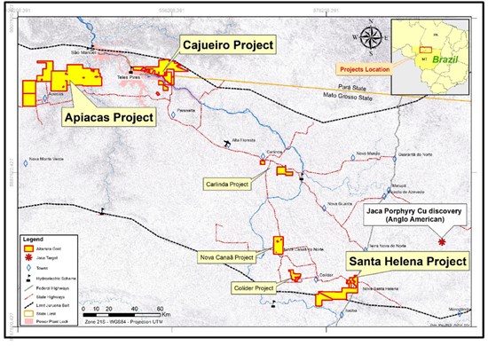
The Santa Helena project is located immediately adjacent to the paved BR-163 federal highway in the state of Mato Grosso and 60km SW of the Jaca porphyry copper deposit which was recently discovered by Anglo American plc (Figure 1).
Figure 1: Location of the Santa Helena, Apiacas and Cajueiro projects.
To view an enhanced version of this graphic, please visit:
https://images.newsfilecorp.com/files/4500/165524_5b606a6b3443a9c8_001full.jpg
There is no history of copper production in the Santa Helena area and previous artisanal mining activity has focused on high-grade gold, hosted in vein structures.
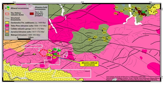
The regional geology (Figure 2) indicates a genetic link between the Teles-Pires intrusives and the Colíder Formation volcanics, which is supported by regional scale geochemistry and geochronology with both units ranging in age from 1806-1757Ma. The Colider Fm consists of lavas and pyroclastic flows with inferred volcanic dome structures. The Teles Pires intrusives consist of alkali-feldspar granites and syenogranites and are interpreted to be the main host to porphyry-style intrusions in the Santa Helena area.
Younger (ca.1400Ma) sedimentary cover of conglomerates and arenites formerly overlay this basement. This cover, which is now reflected as remnant outliers, may have aided the preservation of porphyry alteration zones within the basement.
In a similar manner to the Jaca porphyry district (60km NE), anomalous copper occurrences have associated peripheral gold occurrences. Mapping, soil and rock chip sampling by Altamira has previously identified both extensions to the known vein gold targets in small scale gold workings, plus significant copper, molybdenum and gold anomalies in soils related to areas of porphyry-style alteration in a zone which extends 7km E-W by 4 km N-S, indicating the presence of a very large hydrothermal system. Pervasive “red rock” alteration of the host intrusive rocks is found in many of the holes drilled to date.
Figure 2: Structural interpretation of the setting of the Santa Helena porphyry target in relation to the Jaca porphyry project 60km to the NE.
To view an enhanced version of this graphic, please visit:
https://images.newsfilecorp.com/files/4500/165524_5b606a6b3443a9c8_003full.jpg
Figure 3: Regional magnetics showing interpreted major NE/SW structural discontinuity extending over 60km.
To view an enhanced version of this graphic, please visit:
https://images.newsfilecorp.com/files/4500/165524_5b606a6b3443a9c8_004full.jpg
Figure 4: Detail of soil sample results for copper, showing the clear north-east regional trend. White rectangle shows the area detailed in Figure 5. Prior drill holes for gold are focussed on existing artisanal gold workings and gold-in-soil anomalies which are peripheral to the copper-in soil anomalies.
To view an enhanced version of this graphic, please visit:
https://images.newsfilecorp.com/files/4500/165524_5b606a6b3443a9c8_006full.jpg
Regional airborne magnetics data shows major structures including a significant NE-SW structure passing through the area of current interest (Figure 3). The same trend is evident from the alignment of copper and gold soil anomalies (Figures 4).
A ground magnetic survey has been conducted over this north-eastern copper-in-soil anomaly using survey lines oriented north-south, separated by 50m and with readings every second at walking pace. The data was quality controlled and analysed by consultant geophysicist Mat Cooper of Core Geophysics Western Australia (Figure 5).
Figure 5: Ground magnetics Analytic Signal with copper-in-soil shown as contoured data from 100 x 50m sampling on north-south lines.
To view an enhanced version of this graphic, please visit:
https://images.newsfilecorp.com/files/4500/165524_5b606a6b3443a9c8_007full.jpg
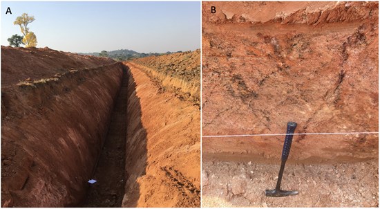
A trench excavated in the western end of the main soil anomaly (Figure 6) showed vein and stockwork structures in saprolite and returned 41m @ 397ppm Cu. Leaching in the surficial environment is common and values in soils or trenches may be significantly depleted in base metals.
Figure 6: Trench within the western sector of the main soil anomaly. Image A indicates the depth of weathering. Image B illustrates relict stockwork veining in saprolite, marked by dark oxide minerals in the wall of the trench.
To view an enhanced version of this graphic, please visit:
https://images.newsfilecorp.com/files/4500/165524_5b606a6b3443a9c8_008full.jpg
Prior drilling around the artisanal gold working (garimpo) to the south-west of the magnetic and copper-in-soil anomaly has shown at least three different generations of veining in drill core (Figure 7), indicating an alteration system that was reactivated in different temperature regimes, currently interpreted as reflecting the distal part of a cooling hydrothermal system associated with a local (porphyry) intrusion. See Press Release dated April 12, 2023 for drill results.
Figure 7: Selected core photos from drillholes DDSTH002,010,012 and 014 drilled to test gold vein and stockwork targets. The samples show syenogranite intrusive with chlorite-secondary biotite, sericite-muscovite and potassium felspar/hematite (“red-rock”) alteration, cut by polyphase veining and brecciation with quartz, calcite, epidote, hematite, magnetite, chlorite (+/- secondary biotite), potassium feldspar and pyrite/chalcopyrite.
To view an enhanced version of this graphic, please visit:
https://images.newsfilecorp.com/files/4500/165524_5b606a6b3443a9c8_009full.jpg
The coherent copper-in-soil anomaly over a porphyry-scale footprint area, combined with the new magnetic data, signalling the presence of both sub-cropping arcuate inferred magnetic-destructive alteration and a major regional fault, provide strong indicators for a porphyry style target for the copper anomaly. Previous drilling for gold, within a radius of 600m of the copper target, provides further concrete support for a porphyry-style setting via intercepts of altered, polyphase veined and brecciated intrusives hosting pyrite and chalcopyrite.
Altamira is in the process of completing ground magnetic surveys over the other three defined copper-in-soil anomalies and plans to accelerate the definition of drill targets for scout diamond drilling.
Qualified Person
Guillermo Hughes, FAIG and M AusIMM., a consultant to the Company as well as a Qualified Person as defined by National Instrument 43-101, supervised the preparation of the technical information in this news release.
Neither the TSX Venture Exchange nor its Regulation Services Provider (as that term is defined in the policies of the TSX Venture Exchange) accepts responsibility for the adequacy or accuracy of this release.
About Altamira Gold Corp.
The Company is focused on the exploration and development of gold projects within western central Brazil. The Company holds 6 projects comprising approximately 190,000 hectares, within the prolific Juruena gold belt which historically produced an estimated 7 to 10Moz of placer gold. The Company’s advanced Cajueiro project has NI 43-101 resources of 5.66Mt @ 1.02 g/t gold for a total of 185,000 oz in the Indicated Resource category and 12.66Mt @ 1.26 g/t gold for a total of 515,000oz in the Inferred Resource category.
On Behalf of the Board of Directors,
ALTAMIRA GOLD CORP.
“Michael Bennett”
Michael Bennett
President & CEO
Tel: 604.676.5660
Toll-Free:1-833-606-6271
info@altamiragold.com
www.altamiragold.com
Forward-Looking Statements
Statements in this document which are not purely historical are forward-looking statements, including any statements regarding beliefs, plans, expectations or intentions regarding the future. It is important to note that actual outcomes and the Company’s actual results could differ materially from those in such forward-looking statements. Except as required by law, we do not undertake to update these forward-looking statements.

To view the source version of this press release, please visit https://www.newsfilecorp.com/release/165524


